Peru Earthquake: Latest Updates, Causes, History, Safety Tips, and What You Need to Know

Introduction: Why Peru Earthquakes Matter
A Peru earthquake is never just a geological event. In a country where the Andes stretch across the landscape and the Pacific Ocean borders the western coast, earthquakes are part of everyday natural risk. Peru sits in one of the world’s most active seismic regions, so residents have learned to take even moderate shaking seriously.
The latest major Peru Earthquake in Peru has once again put seismic activity in the spotlight. On August 20, 2026, a strong earthquake struck the southern Andes in the Ayacucho region. The U.S. Geological Survey (USGS) reported a magnitude of 6.7, while Peru’s Geophysical Institute initially reported the event at 7.2. The difference comes from the way different agencies calculate and revise earthquake measurements.
The Peru Earthquake was deep underground, which helped limit the amount of destructive shaking at the surface. Still, the tremor was widely felt across southern Peru, including areas such as Ica, Arequipa, Huancavelica, Apurimac, Cusco, and Lima. Authorities also reported injuries and structural damage in several locations, showing that a deep earthquake can still create real problems for communities.
Understanding a Peru Earthquake requires more than looking at the magnitude number. Depth, location, building quality, local geology, population density, and secondary hazards all influence the final impact. That is why two Peru Earthquake with similar magnitudes can produce very different outcomes.
What Happened During the Latest Peru Earthquake?
The latest major Peru Earthquake struck on Thursday, August 20, 2026, in Peru’s southern Andes. According to the USGS, the earthquake had a magnitude of 6.7 and occurred at a depth of roughly 66.7 kilometers. Its epicenter was approximately 38 kilometers northwest of Upahuacho in the Parinacochas province of the Ayacucho region.
The Peru Earthquake was strong enough to be felt across a broad part of southern Peru. Reports indicated shaking in Ica, Arequipa, Huancavelica, Apurimac, Cusco, and Lima. People in affected communities reportedly left buildings during the shaking because of concerns about structural safety and possible aftershocks.
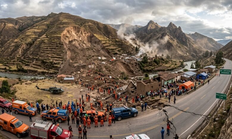
Initial reports suggested that the Peru Earthquake caused limited but noticeable damage. Authorities reported damage to houses, health centers, and a school in several districts. Rockfalls were also reported near Coracora, highlighting one of the major challenges of earthquakes in mountainous areas.
There were also reports of people being injured while evacuating. The Peruvian Navy ruled out a tsunami threat from the event, which was particularly important for coastal communities. The absence of a tsunami threat helped prevent an already stressful situation from becoming even more dangerous.
Why Does Peru Have So Many Peru Earthquake?
Peru experiences frequent Peru Earthquake because of its position along a major tectonic boundary. The Nazca Plate is moving beneath the South American Plate, a process known as subduction. This enormous geological interaction is responsible for much of the seismic activity along the western edge of South America.
Imagine two enormous pieces of the Earth’s crust slowly pushing against each other. The movement does not always happen smoothly. Instead, stress can build up underground for years or even centuries. When that stored energy is suddenly released, the ground shakes.
This tectonic activity also helped create the Andes Mountains. The same forces responsible for Peru’s Peru Earthquake risk have played a major role in shaping the country’s dramatic mountain landscape. In other words, Peru’s spectacular geography and its earthquake hazard are closely connected.
The Instituto Geofísico del Perú explains that the interaction between the Nazca and South American plates is directly related to Peru Earthquake across the country. Peru is therefore considered a highly seismic nation, making earthquake preparedness an important part of public safety.
Peru and the Pacific Ring of Fire
Peru is part of the Pacific Ring of Fire, a huge zone surrounding much of the Pacific Ocean that is known for intense tectonic and volcanic activity. Many countries around the Pacific experience frequent Peru Earthquake because of the movement and interaction of several tectonic plates.
The Ring of Fire is not a single fault. Instead, it is a broad region where multiple plate boundaries and geological processes create unusually high levels of seismic activity. Peru’s location along the western edge of South America puts it directly within this wider system.
This explains why earthquakes are not unusual in Peru. Small tremors occur regularly, while larger Peru Earthquake happen less frequently but can cause significant destruction. The risk is especially important along parts of the western and southern regions.
USGS research on South American seismic hazards identifies Peru and other western South American countries as areas where damaging ground shaking is possible. The research also emphasizes that stronger construction and appropriate building design can reduce losses during future Peru Earthquake.
How Deep Was the 2026 Peru Earthquake?
One of the most important details about the August 20 Peru Earthquake was its depth. The USGS placed the earthquake at approximately 66.7 kilometers underground. That is considerably deeper than many earthquakes that cause severe surface destruction.
Earthquake depth matters because seismic energy changes as it travels toward the surface. A deep Peru Earthquake can still be felt across a large region, but the shaking at the surface may be different from that produced by a shallow earthquake of similar magnitude.
This helps explain why the August 2026 Peru Earthquake was widely felt but did not produce the kind of catastrophic destruction associated with some shallower earthquakes. The head of Peru’s Geophysical Institute also noted that the depth helped reduce its destructive potential.
However, deep does not mean harmless. Communities can still experience structural damage, falling objects, landslides, panic, and injuries. The latest event demonstrated exactly why residents should remain prepared even when scientists describe an Peru Earthquake as relatively deep.
What Damage Did the Peru Earthquake Cause?
Initial reports after the August 2026 Peru Earthquake indicated damage in several communities. Authorities reported that houses, health facilities, and a school were affected in parts of Ayacucho and nearby areas. The reported damage was limited compared with some of Peru’s historic disasters, but it was still significant for the communities directly affected.
Rockfalls were another concern. This is particularly important in the Andes because steep slopes and unstable rock can become dangerous during strong shaking. Even when buildings survive, roads can become blocked by falling rocks and debris.
The earthquake also caused people to evacuate buildings. During an earthquake, injuries do not always happen because a building collapses. People can be hurt by falling furniture, broken glass, debris, or accidents while attempting to escape.
Because assessments continue after major earthquakes, initial damage figures should always be treated as preliminary. Remote mountain communities can be difficult to reach quickly, and authorities may need additional time to inspect buildings, roads, bridges, hospitals, and other infrastructure.
Why Earthquake Magnitude Can Change
People often become confused when different organizations report different magnitudes for the same earthquake. That happened with the August 20 Peru earthquake. Peru’s Geophysical Institute initially reported a magnitude of 7.2, while the USGS later reported 6.7.
This does not necessarily mean that one organization made a mistake. Earthquake magnitude can be calculated using different methods and data. Preliminary measurements are also frequently revised as more seismic information becomes available.
Modern earthquake monitoring systems collect data from networks of seismometers. Scientists use these measurements to estimate the earthquake’s location, depth, magnitude, and other characteristics. Early numbers can therefore change as additional data are processed.
For ordinary readers, the most important point is simple: the magnitude number is only one part of the story. Depth, distance from populated areas, local soil conditions, building construction, and secondary hazards all matter when determining how dangerous an earthquake may be.
Peru’s Long History of Major Earthquakes
Peru has experienced devastating earthquakes throughout its history. Historical records compiled by Peruvian scientists describe major earthquakes affecting the country over several centuries, including powerful events along the coast and in southern Peru.
One particularly important example occurred in 1970. The earthquake struck northern coastal Peru and became one of the country’s most devastating natural disasters. The event demonstrated how earthquakes can trigger secondary hazards and cause enormous losses far beyond the immediate shaking.
Another major earthquake occurred in the Ica region in 2007. The magnitude 7.9 earthquake caused severe destruction and killed nearly 600 people, according to reports about Peru’s earthquake history.
These historical events remain important because they show that earthquake risk cannot be measured only by looking at what happened recently. Peru’s geological setting means that strong earthquakes will continue to be possible, making long-term preparedness essential.
The 2007 Peru Earthquake and What It Taught the Country
The 2007 earthquake in the Ica region remains one of the most remembered recent disasters in Peru. Its magnitude and shallow offshore setting allowed powerful shaking to affect communities across a large area.
The disaster showed how vulnerable homes and public infrastructure can become when they are not designed or maintained to withstand strong ground motion. It also highlighted the importance of emergency response, communication, medical services, and transportation after a major earthquake.
One lesson from earthquake science is that the same magnitude can produce very different levels of damage depending on where an earthquake occurs. A densely populated area with vulnerable buildings faces a much greater risk than a remote region with fewer structures.
The 2007 disaster therefore remains part of the broader discussion about earthquake preparedness in Peru. It is a reminder that building standards and community education can be just as important as earthquake monitoring.
Earthquake Risks in Peru’s Andes
The Andes create a unique earthquake environment. Mountains can amplify certain secondary hazards, especially landslides and rockfalls. Roads crossing steep terrain may become difficult or impossible to use after strong shaking.
This can make emergency response more complicated. A damaged road can delay ambulances, rescue teams, food deliveries, and engineering crews. In remote communities, even relatively limited structural damage can become a serious problem if transportation links are interrupted.
Mountainous terrain also means that residents may face hazards beyond collapsing buildings. Falling rocks, unstable slopes, damaged bridges, and blocked roads can all threaten communities after an earthquake.
For this reason, earthquake preparedness in the Andes requires more than preparing individual homes. Authorities must also consider transportation networks, communications systems, hospitals, schools, water supplies, and emergency access routes.
Could a Peru Earthquake Cause a Tsunami?
Not every earthquake in Peru creates a tsunami. A tsunami generally requires a particular combination of factors, including significant movement of the seafloor and an earthquake occurring in a suitable offshore setting.
The August 20, 2026 earthquake did not create a tsunami threat. The Peruvian Navy confirmed that there was no tsunami danger associated with the event.
This distinction matters because Peru has a long Pacific coastline. Coastal communities naturally pay close attention to earthquake information, particularly when a strong earthquake occurs near or beneath the ocean.
People should not assume that every strong earthquake means a tsunami is coming. Instead, they should follow official warnings from Peru’s authorities and recognized tsunami-monitoring agencies.
At the same time, coastal residents should know their local evacuation routes. If a strong earthquake occurs near the coast and authorities issue a tsunami warning, people should move quickly to safe locations rather than waiting for additional confirmation from social media or unofficial sources.
How Aftershocks Affect Peru
After a significant earthquake, smaller earthquakes called aftershocks can follow. They occur as the Earth’s crust adjusts after the main rupture. Some are barely noticeable, while others can be strong enough to cause additional damage.
Aftershocks can be especially dangerous for buildings that were already weakened by the main earthquake. A structure that appears safe from the outside may have hidden damage that becomes worse during another round of shaking.
People can also become psychologically exhausted when earthquakes continue. The uncertainty of not knowing when the next tremor will occur can make residents anxious, especially after a damaging event.
For this reason, authorities inspect important infrastructure and continue monitoring seismic activity after major earthquakes. Residents should also avoid entering visibly damaged buildings until professionals have determined that they are safe.
What Should You Do During a Peru Earthquake?
The safest general response during strong shaking is to protect yourself from falling objects. In many situations, people should Drop, Cover, and Hold On. Getting underneath sturdy furniture can provide protection from debris, while covering the head and neck reduces the chance of serious injury.
Running outside while the ground is violently shaking can be dangerous. People may encounter falling glass, debris, damaged walls, power lines, or other hazards. Staying away from windows and objects that could fall is generally safer during the strongest shaking.
If you are outdoors, move away from buildings, trees, utility poles, and other structures that could collapse or shed debris. In a mountainous region, also remain aware of possible rockfalls and unstable slopes.
After the shaking stops, check yourself and others for injuries. If it is safe to do so, move away from damaged structures and follow instructions from emergency authorities. Avoid spreading unverified information, particularly when authorities are still assessing the situation.
How Peru Can Reduce Earthquake Damage
Earthquakes cannot be stopped, but their consequences can be reduced. One of the most effective strategies is earthquake-resistant construction. Buildings designed to withstand strong shaking have a much better chance of protecting occupants.
Building codes are therefore a critical part of earthquake safety. Engineers use information about expected ground motion, soil conditions, construction materials, and structural behavior when designing buildings in seismic regions.
Existing buildings are also important. A city can have modern earthquake-resistant structures alongside older buildings that were never designed for strong shaking. Retrofitting vulnerable structures can therefore play a major role in reducing future losses.
USGS research on South American seismic hazards emphasizes that construction designed for strong ground motion can reduce casualties and damage in areas with high seismic risk.
Why Earthquake Preparedness Matters for Ordinary Families
Earthquake preparedness does not need to be complicated. Families can begin by identifying safer areas inside their homes, discussing evacuation plans, and keeping important supplies accessible.
A basic emergency kit can include drinking water, food that does not require refrigeration, flashlights, batteries, first-aid supplies, essential medications, important documents, and a portable way to receive emergency information.
Families should also decide how they will communicate if mobile networks become overloaded. Having a simple meeting point can be useful when family members are separated at school, work, or elsewhere when an earthquake occurs.
Perhaps the most important step is practicing. People often freeze during unexpected emergencies because they have never considered what to do. A short earthquake drill can make the correct response much more automatic.
How Scientists Monitor Earthquakes in Peru
Earthquake monitoring is an ongoing scientific process. Seismometers installed across Peru and around the world detect vibrations traveling through the Earth. Scientists use this information to locate earthquakes and estimate their characteristics.
The Instituto Geofísico del Perú plays an important role in monitoring seismic activity within the country. The institution regularly provides information about earthquakes and promotes public awareness of Peru’s seismic risk.
International organizations such as the USGS also monitor earthquakes in Peru. Their networks allow scientists to compare data from different locations and produce rapid estimates of magnitude, depth, and epicenter.
This information is extremely useful for emergency management. The faster authorities understand where an earthquake occurred and how strong it was, the faster they can prioritize inspections, public communication, and emergency response.
Can Scientists Predict the Next Peru Earthquake?
One of the biggest misconceptions about earthquakes is that scientists can accurately predict exactly when the next major earthquake will occur. At present, earthquake science cannot provide reliable predictions with a specific date, time, location, and magnitude.
Scientists can identify areas where earthquake hazards are high. Peru is clearly one of those areas because of its tectonic setting and history of major earthquakes.
Researchers can also study faults, historical earthquakes, plate movement, and seismic patterns to understand long-term risk. These studies are valuable for urban planning and building design, even though they cannot tell residents exactly when the next major earthquake will strike.
That is why preparedness is more useful than trying to predict a specific event. Peru’s earthquake risk is a long-term reality, so communities benefit from preparing before the next significant tremor occurs.
What the Latest Peru Earthquake Means for the Future
The August 2026 earthquake is another reminder that Peru remains one of South America’s most seismically active countries. The event was strong enough to be felt across a wide area and caused localized damage, yet its depth helped limit the overall destructive impact.
It would be a mistake, however, to interpret one relatively limited earthquake as evidence that Peru’s earthquake risk has disappeared. Earthquake activity does not work like a schedule where one event permanently removes all future danger.
Instead, every earthquake provides scientists and authorities with additional information. Data from each event can improve understanding of local faults, ground shaking, building performance, and emergency response.
For residents, the practical message is straightforward: stay informed, prepare your home, understand local evacuation procedures, and rely on official information during an emergency.
Final Thoughts on Peru Earthquake Risk
A Peru earthquake can range from a small tremor that most people barely notice to a major disaster capable of changing entire communities. The country’s location along the Nazca-South American plate boundary means earthquakes will remain a natural part of life.
The August 20, 2026 earthquake demonstrates how complicated these events can be. Different agencies initially reported different magnitudes, the earthquake occurred deep beneath the Andes, shaking was felt across multiple regions, and localized damage and injuries were reported. At the same time, no tsunami threat was identified.
Peru’s history provides plenty of evidence that preparation matters. Strong construction, effective monitoring, public education, emergency planning, and responsible communication can all reduce the human cost of future earthquakes.
Ultimately, the goal is not to live in fear of earthquakes. It is to understand the risk and prepare intelligently. When people know what to do before, during, and after an earthquake, they are in a much stronger position to protect themselves, their families, and their communities.